Posts

Showing posts with the label Turkey

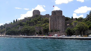
Rumelian Castle "Rumelihisarı", The Strait-Cutter
Image
Rumelian Castle "The Strait-Cutter" Rumelihisarı (Rumelian Castle) or Boğazkesen (literally meaning "the Strait-Cutter") is a fortress built by Sultan Mehmed Khan II, located at the European side and the narrowest point of the Bosphorus strait, just opposite of Anadoluhisarı (Anatolian Castle) on the Anatolian side. The construction began on 15 April 1452, the fortress was completed in a record time of 4 months and 16 days on 31 August 1452. The purposes of the structure were to manage the passing ships in the bosphorus, to create a military-financial control point, and to provide a strong fulcrum-resistance base.  The width of the castle walls was thrice the size of Constantinople, which was 2,5 m. The canon ball technology at  that period was insufficient to destroy this walls with a thickness of 7 m.  Rumeli Hisarı "Boğazkesen" Rumelihisarı ya da Boğazkesen İstanbul Boğazının Avrupa yakasında ve en dar noktasında tam Anad...

The Fountain of Sultan Ahmed Khan, Istanbul

Image
The fountain of Sultan Ahmed The fountain of Sultan Ahmed, Istanbul, Turkey.  The fountain of Sultan Ahmed Khan (1673-1736) was built in 1728 by architect Ahmet Ağa, in the style of the Tulip period and located in the great square in front of the Imperial Gate of Topkapi Palace.    A photomechanical print published between ca. 1890 and ca. 1900 by Detroit Publishing Company. From the section of “Views of People and sites in Turkey” in the Photochrom (ink-based photolithographs) print collection of The Library of Congress.  Sultan Ahmet Çeşmesi Sultan Ahmet Çeşmesi, İstanbul, Türkiye.  Sultan Ahmet Han Çeşmesi (1673-1736) Mimar Ahmet Ağa tarafından 1728 yılında, Lale döneminin tarzında inşa edilmiş olup Topkapı Sarayı İmparatorluk Kapısı önündeki, büyük meydanda yer alır.  1890 ile 1900 yılları arasında Detroit Publishing Company tarafından yayınlanmış bir fotomekanik baskı. Kongre Kütüphanesi Photochrom (mürekkep tabanlı fotolitog...

Map of Turkia and Turkish Empire, 1593 Antwerp

Image
Map of Turkia and Turkish Empire Turcia Turci Cive Imperii (Turkia and Turkish Empire) 1593 Antwerp, Gerard De Jode (1509–1591). The map of Turkey and Turkish Empire from the 1593 edition of Gerard De Jode's “Speculum Orbis Terrarum” published by his son Cornelis.  The map includes two title cartouches and three sailing ships. Noah's Ark appears on Mount Ararat. The upper cartouche indicate the geographical information “Natoliam modern, dicunt eam partem quam Asiam Minorem apellavere veteres” the lower cartouche “Turcia Turci Cive Imperii” indicate that it is a map of Turkia and Turkish Empire.  Türkiye ve Türk İmparatorluğu Haritası Turcia Turci Cive Imperii (Türkiye ve Türk İmparatorluğu) 1593 Anvers, Gerard De Jode (1509–1591). Gerard De Jode’un “Speculum Orbis Terrarum” atlasının oğlu Cornelis tarafından yayınlanan 1593 yılı baskısından Türkiye ve Türk İmparatorluğu haritası. İki ayrı kitabe ve üç yelkenli geminin yer aldığı harita Nuh'un Gemisini...

Trabzon - Atatürk Pavilion "Atatürk Köşkü"

Image
Atatürk Pavilion The building which is surrounded by pine trees, located at Soguksu district was constructed in 1890. Atatürk visited Trabzon for the first time on 15 September 1924, during his short sightseeing tour to Soguksu, he saw the pavilion and liked it very much. In June 1937, Atatürk visited Trabzon for a third and last time, he stayed in this building for two nights. On 6 August 1942, the pavilion was bought by the Trabzon Municipality to be redesigned as a museum. Today the pavilion, with its large flower garden, is open to visitors as the Atatürk Museum under the management of the Trabzon municipality.  Atatürk Köşkü Soğuksu semtinde bulunan çam ağaçları ile çevrili bina 1890 yılında inşa edilmiştir. 15 Eylül 1924 tarihinde ilk kez Trabzon'u ziyaret eden Atatürk Soğuksuya yaptığı kısa gezi turu sırasında köşkü görmüş ve çok beğenmiştir. Haziran 1937'de, Trabzon'u üçüncü ve son kez ziyaret eden Atatürk, iki gece bu binada konaklamışt...

Ortelius's first map of the Turkish Empire

Image
Turcici Imperii Descriptio, Antwerp 1570,  Abraham ORTELIUS (1527 - 1598)  “Turkish Empire Description” Ortelius's first map of the Turkish Empire from “Theatrum Orbis Terrarum” the first modern atlas of the world. The map is based upon Gastaldi's wall map of Asia. Includes an ornate cartouche, four sailing vessels and a sea monster in the Black Sea. The second edition of the map was published from 1579 onward, with a distinctly different cartouche, but unchanged cartographic features. Turcici Imperii Descriptio, Anvers 1570, Abraham ORTELIUS (1527 - 1598)  “Türk İmparatorluğu Tasviri” İlk modern dünya atlası sayılan Ortelius’un "Theatrum Orbis terrarum" atlasının ilk baskısında yer alan Türk İmparatorluğu haritası. Harita Gastaldi’nin, Asya duvar haritası temel alınarak hazırlanmıştır. Süslü bir kitabeye sahip olan haritada dört yelkenli gemi ve Karadeniz'de bir deniz canavarı vardır. 1579 yılından itibaren yayınlanan ikinci baskı farklı bir kitab...