Posts

Showing posts with the label Turkish empire

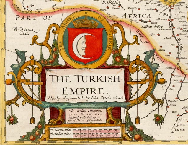
The Turkish Empire. The Armes of Turkie, London, 1626
Image
Map of the Turkish Empire The Turkish Empire, London 1626 John SPEED (1552-1629) One of the most decorative maps of the Turkish Empire issued in the 17th Century. The first map of the region published in England, decorated with eight Turkish town plan (Famagusta, Damascus, Cairo, Jerusalem, Constantinople, Rhodes, Alexandria and Ormus) and ten costumed figures and a large cartouche. Size 390 x 510 mm Türk İmparatorluğu Haritası Türk İmparatorluğu, Londra 1626, John SPEED (1552-1629) Türk İmparatorluğu'nun 17. yüzyılda yayınlanmış en dekoratif haritalarından biridir.  Sekiz Türk şehrinin planı, ( Mağusa, Şam, Kahire, Kudüs, İstanbul, Rodos, İskenderiye ve Hürmüz ) on kostümlü figür ve büyük bir kitabe ile süslenmiş 390 x 510 mm boyutlarındaki harita bölgenin İngiltere'de yayınlanan ilk haritasıdır.

Procession of the Sultan by Jean Baptiste Van Mour (1671-1737)

Image
The Turkish Sultan’s Procession The Turkish Sultan’s Procession in Istanbul. Painting by Jean Baptiste Van Mour (1671-1737). Jean Baptiste Vanmour or Van Mour was a Flemish-French painter, remembered for his detailed portrayal of life in the Turkish Empire during the Tulip Era and the rule of Sultan Ahmed Khan III. Türk Sultanının geçit töreni İstanbul'da Türk Sultanının geçit töreni. Jean Baptiste Van Mour  (1671-1737) tarafından yapılan resim. Jean Baptiste Vanmour ya da Van Mour, Lale Devri döneminde ve III. Sultan Ahmet Hanın saltanatı sırasında Türk İmparatorluğundaki yaşamı detaylandıran tasvirleri ile hatırlanan Flaman asıllı bir Fransız ressamdı.

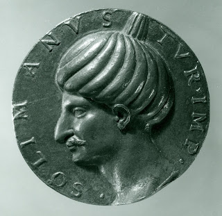
Sulaiman "Süleyman", Turkish Emperor (1520–1566)

Image
Medal of Sultan Sulaiman Khan the Magnificent  Sulaiman, Turkish Emperor (1520–1566). The bronze medal of Sultan Sulaiman Khan the Magnificent  (1494-1566), Northern Italian, 1525. Diameter: 12,8 cm.  Inscription :  “• SOLIMANVS• TVR• IMP•”, SOLYMANVS TVR[carum] IMP[erator], (Sulaiman, Turkish Emperor ).  Kanuni Sultan Süleyman Han Madalyonu Süleyman Türk İmparatoru (1520–1566).  Bronz Kanuni Sultan Süleyman Han (1494-1566) madalyonu. Kuzey İtalya, 1525. Çap: 12,8 cm.  Yazıt :  “• SOLIMANVS• TVR• IMP•”,  SOLYMANVS TVR[carum] IMP[erator], ( Süleyman, Türk İmparatoru)

Map of the Turkish Empire, Amsterdam 1606, Jodocus Hondius

Image
Turkish Empire Image Turcici Imperii Imago, Amsterdam 1606, Jodocus Hondius (1563 – 1612) Map of the Turkish Empire, showing the Turkish territories in the Balkans, Anatolia, Levant, Arabia and North Africa, published by  Hondius in "Atlas sive Cosmographicae Meditationes de Fabrica Mundi et Fabricati figura" (Atlas of the world: finely engraved and drawn) in 1606. The map has a decorative cartouche with the portrait of Sultan Mehmet Khan II which refers to him as "Sultan Mahomet Turcorum Imperat 2."   Türk İmparatorluğu Görünümü Turcici Imperii Imago, Amsterdam 1606, Jodocus Hondius (1563-1612).  Balkanlar, Anadolu, Levant, Arabistan ve Kuzey Afrikadaki Türk topraklarını gösteren,Hondius’un “Atlas sive Cosmographicae Meditationes de Fabrica Mundi et Fabricati figura” (Dünyanın atlası: incelikle işlenmiş ve çizilmiş)  Dünya Atlasında 1606 yılında yayınlanan, Türk İmparatorluğu haritası. Fatih Sultan Mehmet Han’ nın bir portresi bulunan har...

Sultan Orchan "Orhan" Khan (1281 – 1362)

Image
Sultan Orchan Khan Sultan Orchan Khan (1281 – 1362) from "Portraits of the Emperors of Turkey" - London, 1815 by  John Young. This sheet shows the second sultan of the Ottoman dynasty, Sultan Orchan Khan, Orchan "Orhan" reigned from 1326 to 1360, spending most of his time on the battlefield. He acquired the Dardanelles and areas around Constantinople, established longstanding military protocols and costumes, and was the first Ottoman dynasty sultan to mint coins in his own name. The vignette below records an event which, according to Ottoman writers, forms a striking epoch in Turkish history; namely, the first passage of Turks over the Hellespont into Europe, under Soliman, the son Orchan. The invading army, after walking over the ruins of Troy, embarked near Abydos. Sultan Orhan Han "Orhan Gazi" Sultan Orhan Han (1281 – 1362) “Türkiye'nin İmparatorlarının Portreleri” (Portraits of the Emperors of Turkey) - London, 1815  John You...

Map of Turkia and Turkish Empire, 1593 Antwerp

Image
Map of Turkia and Turkish Empire Turcia Turci Cive Imperii (Turkia and Turkish Empire) 1593 Antwerp, Gerard De Jode (1509–1591). The map of Turkey and Turkish Empire from the 1593 edition of Gerard De Jode's “Speculum Orbis Terrarum” published by his son Cornelis.  The map includes two title cartouches and three sailing ships. Noah's Ark appears on Mount Ararat. The upper cartouche indicate the geographical information “Natoliam modern, dicunt eam partem quam Asiam Minorem apellavere veteres” the lower cartouche “Turcia Turci Cive Imperii” indicate that it is a map of Turkia and Turkish Empire.  Türkiye ve Türk İmparatorluğu Haritası Turcia Turci Cive Imperii (Türkiye ve Türk İmparatorluğu) 1593 Anvers, Gerard De Jode (1509–1591). Gerard De Jode’un “Speculum Orbis Terrarum” atlasının oğlu Cornelis tarafından yayınlanan 1593 yılı baskısından Türkiye ve Türk İmparatorluğu haritası. İki ayrı kitabe ve üç yelkenli geminin yer aldığı harita Nuh'un Gemisini...

Medal commemorating Hayreddin Barbarossa "Hızır Reis"

Image
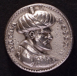
Admiral Hayreddin Barbarossa Silver medal commemorating Admiral Khair Ad-din (Hayreddin) Barbarossa, Grand Admiral (Kaptan-ı Derya) of the Turkish Empire. Made by Ludwig Neufarer, Germany, 1533, diameter: 27 mm.  Inscriptions on the obverse in Italian,:  “BARBA ROSSA”  (Red Beard)  Inscriptionson the reverse in Turkish:   “HAYREDDİN PAŞA CEZAYİR, SULTAN"  (Khair Ad-din Pasha Algiers, Sultan) Amiral Barbaros Hayreddin Paşa  Türk İmparatorluğu Kaptan-ı Deryası Amiral Barbaros Hayreddin Paşa anısına gümüş madalyon, Ludwig Neufarer, Almanya, 1533, çap: 27 mm.  Yazıtlar ön yüzde italyanca:  “BARBA ROSSA”  (Kızıl Sakal)  Arka yüzde Türkçe: “HAYREDDİN PAŞA CEZAYİR, SULTAN”

Sultan Othman "Osman" Khan the first (1258 – 1326)

Image
Sultan Othman Khan I Sultan Othman Khan the first (1258 – 1326) from Portraits of the Emperors of Turkey - London, 1815 by  John Young. Sultan Selim III commissioned English engraver John Young (1755- 1825) to make a series after portraits of the emperors of Turkey before 1807, but production halted when janissaries assassinated the sultan. Mahmoud II ascended the throne, and John Young resumed work in 1810. This sheet shows the founder of the Ottoman dynasty, Othman (Osman) the first. He reigned from 1299 to 1326 and was said to be a great tactician known for his stern demeanor. The vignette below represents Othman in his camp, sitting under an imperial canopy, attended by his courtiers, and issuing orders to his officers. Sultan I. Osman Han "Osman Gazi" Sultan I. Osman Han (1258 - 1326) “Türkiye'nin İmparatorlarının Portreleri” (Portraits of the Emperors of Turkey) - London, 1815,  John Young. Sultan III. Selim Han 1807 öncesinde Türkiye'n...

The tomb "Türbe" of Ertuğrul Bey Ghazi

Image
The tomb of Ertuğrul Bey Ghazi The tomb of Ertuğrul Bey Ghazi, Söğüt, Bilecik, Turkiye. The tomb belongs to Ertuğrul Ghazi (1198 – 1281), the Bey (Leader) of Kayı of Oghuz, a fore Ruler of the Seljuk dynasty and the father of Osman Ghazi (Osman I) who is the founder of the Ottoman dynasty. The tomb is in town of Söğüt with in the borders of Bilecik province and is built in 14th century but the actual building date is unknown. Söğüt has been handed out to Ertuğrul Ghazi  in exchange for his services by Sultan Alaad-Din Kay Qubadh the first of the Seljuks. It is assumed that  the tomb has been built with the orders by his great grandson Chelebi Sultan Mehmet Khan the first. It has been restored in 1886 by Sultan the second Abdulhamid Khan.      Ertuğrul Bey Gazi Türbesi   Ertuğrul Bey Gazi Türbesi, Söğüt, Bilecik, Türkiye. Oğuzların Kayı boyu Beyi, Selçuklu hanedanı dönemi Uç Beyi ve Osmanlı hanedanının kurucusu Osman Bey Gazinin babas...

A variation of Ortelius's map of the Turkish Empire

Image
Turcici Imperii Descriptio  “Turkish Empire Description”  ORTELIUS Abraham (1527 - 1598), Antwerp 1581   A variation of Ortelius's map of the Turkish Empire from “Theatrum Orbis Terrarum” the first modern atlas of the world with a different cartouche. The map is based upon Gastaldi's wall map of Asia. Includes an ornate cartouche, four sailing vessels and a sea monster in the Black Sea. This second edition of the map was published from 1579 onward, with a distinctly different cartouche, but unchanged cartographic features.  Turcici Imperii Descriptio  “Türk İmparatorluğu Tasviri” Abraham ORTELIUS (1527 - 1598), Anvers 1581 İlk modern dünya atlası sayılan Ortelius’un  "Theatrum Orbis terrarum" atlasından, ilk baskısından farklı bir kitabeye sahip Türk İmparatorluğu haritası varyasyonu. Harita Gastaldi’nin, Asya duvar haritası temel alınarak  hazırlanmıştır. Süslü bir kitabeye sahip olan haritada dört yelkenli gemi ve ...

Last Expedition of Sultan Suleiman Khan The Magnificent "Szigetvar"

Image
The heroic death of Zriny at Szigetvar: the 8. Sept. 1566 La mort héroïque de Zriny à Szigetvar, le 8. Sept. 1566 (The heroic death of Zriny at Szigetvar: the 8. Sept. 1566). A drawing of artist J. Osolsobie, describing a scene from the Szigetvár siege, published by Ferdinánd Tomala at 1830. The battle at 1566 was fought between the Habsburgs allied forces under the leadership of Nikola Šubić Zrinski (Hungarian: Zrínyi Miklós) and the Turkish army. The Siege of Szigetvár (Turkish: Zigetvar Kuşatması) was the last expedition of the Turkish army, under the command of Sultan Suleiman Khan the Magnificent. Suleiman had passed away in his tent from natural causes, at September 7th, just a day before the final charge to the fortress, which ended with Turkish victory. Zirinyi’nin Zigetvar'da kahramanca ölümü: 8 Eylül 1566 La mort héroïque de Zriny à Szigetvar, le 8. Sept. 1566 (Zirinyi’nin Zigetvar'da kahramanca ölümü: 8 Eylül 1566). 1830'da Ferdinand Tomala...

A Jereed "Cirit" Game, 1891

Image
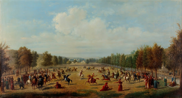
A Jereed Game in Kağıthane A Jereed Game in Kağıthane, Luigi Acquarone (from Antoine Ignace Melling) Oil on canvas, 65.5 x 120 cm, 1891. This painting by Acquarone, is an oil copy of the engraving Kağıthane, published in Melling’s book. Jereed “Cirit” is a traditional Turkish equestrian war game played by Turks trough out history. Mainly, jereed was played to improve the cavalry’s attack and defence skills, and to whip up their enthusiasm for battle. Under Ottoman dynasty rule a superior class of cavalrymen known as "cündi" was formed from those skilled at jereed. Kâğıthane’de Cirit Kâğıthane’de Cirit, Luigi Acquarone (Antoine Ignace Melling’ten). Tuval üstüne yağlıboya, 65,5×120 cm, 1891. Acquarone'nin bu tablosu, Melling’in kitabında yayınlanan Kâğıthane gravürünün bir yağlıboya kopyasıdır. Cirit, Türklerin tarih boyunca oynadığı geleneksel bir Türk atlı savaş oyunudur. Esas olarak, süvarinin saldırı ve savunma becerilerinin geliştirilmesi ve c...

Türckische Cammer “Turkish Chamber”

Image
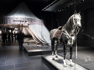
Türckische Cammer “Turkish Chamber” In the Dresden Residenzschloss  “Royal Palace” Armoury, Dresden State Art Collections The Türckische Cammer in Dresden is one of the most significant collections of Turkish art from Ottoman Dynasty period outside Turkey. Exhibition presents more than 600 individual pieces of Turkish art. The largest object is the three-mast Turkish tent brought to Dresden in 1730. This 20 m long, 8 wide and 6 m high tent gives the viewer a sense of being under a second sky of gold and silk. The tent is made of satin, cotton and gilt leather; its restoration lasted 14 years. In addition, there are eight life-sized, carved wooden horses and a group of Turkish bows with original strings, the oldest of which dates from 1586.  Also shown are weapons, chain mail armours, helmets, flags and costumes. Türckische Cammer "Türk Salonu" Dresden Residenzschloss “Kraliyet Sarayı” Silahhanesi, Dresden Eyalet Sana...

Ortelius's first map of the Turkish Empire

Image
Turcici Imperii Descriptio, Antwerp 1570,  Abraham ORTELIUS (1527 - 1598)  “Turkish Empire Description” Ortelius's first map of the Turkish Empire from “Theatrum Orbis Terrarum” the first modern atlas of the world. The map is based upon Gastaldi's wall map of Asia. Includes an ornate cartouche, four sailing vessels and a sea monster in the Black Sea. The second edition of the map was published from 1579 onward, with a distinctly different cartouche, but unchanged cartographic features. Turcici Imperii Descriptio, Anvers 1570, Abraham ORTELIUS (1527 - 1598)  “Türk İmparatorluğu Tasviri” İlk modern dünya atlası sayılan Ortelius’un "Theatrum Orbis terrarum" atlasının ilk baskısında yer alan Türk İmparatorluğu haritası. Harita Gastaldi’nin, Asya duvar haritası temel alınarak hazırlanmıştır. Süslü bir kitabeye sahip olan haritada dört yelkenli gemi ve Karadeniz'de bir deniz canavarı vardır. 1579 yılından itibaren yayınlanan ikinci baskı farklı bir kitab...