Posts

Showing posts with the label Antik harita

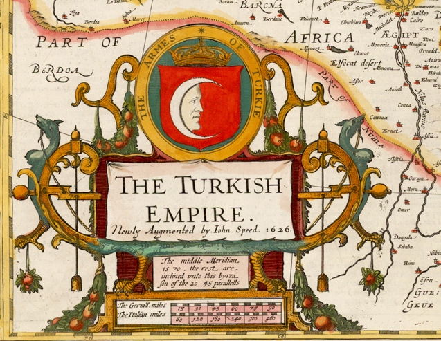
The Turkish Empire. The Armes of Turkie, London, 1626
Image
Map of the Turkish Empire The Turkish Empire, London 1626 John SPEED (1552-1629) One of the most decorative maps of the Turkish Empire issued in the 17th Century. The first map of the region published in England, decorated with eight Turkish town plan (Famagusta, Damascus, Cairo, Jerusalem, Constantinople, Rhodes, Alexandria and Ormus) and ten costumed figures and a large cartouche. Size 390 x 510 mm Türk İmparatorluğu Haritası Türk İmparatorluğu, Londra 1626, John SPEED (1552-1629) Türk İmparatorluğu'nun 17. yüzyılda yayınlanmış en dekoratif haritalarından biridir.  Sekiz Türk şehrinin planı, ( Mağusa, Şam, Kahire, Kudüs, İstanbul, Rodos, İskenderiye ve Hürmüz ) on kostümlü figür ve büyük bir kitabe ile süslenmiş 390 x 510 mm boyutlarındaki harita bölgenin İngiltere'de yayınlanan ilk haritasıdır.

Map of the Turkish Empire, Amsterdam 1606, Jodocus Hondius

Image
Turkish Empire Image Turcici Imperii Imago, Amsterdam 1606, Jodocus Hondius (1563 – 1612) Map of the Turkish Empire, showing the Turkish territories in the Balkans, Anatolia, Levant, Arabia and North Africa, published by  Hondius in "Atlas sive Cosmographicae Meditationes de Fabrica Mundi et Fabricati figura" (Atlas of the world: finely engraved and drawn) in 1606. The map has a decorative cartouche with the portrait of Sultan Mehmet Khan II which refers to him as "Sultan Mahomet Turcorum Imperat 2."   Türk İmparatorluğu Görünümü Turcici Imperii Imago, Amsterdam 1606, Jodocus Hondius (1563-1612).  Balkanlar, Anadolu, Levant, Arabistan ve Kuzey Afrikadaki Türk topraklarını gösteren,Hondius’un “Atlas sive Cosmographicae Meditationes de Fabrica Mundi et Fabricati figura” (Dünyanın atlası: incelikle işlenmiş ve çizilmiş)  Dünya Atlasında 1606 yılında yayınlanan, Türk İmparatorluğu haritası. Fatih Sultan Mehmet Han’ nın bir portresi bulunan har...

Map of Turkia and Turkish Empire, 1593 Antwerp

Image
Map of Turkia and Turkish Empire Turcia Turci Cive Imperii (Turkia and Turkish Empire) 1593 Antwerp, Gerard De Jode (1509–1591). The map of Turkey and Turkish Empire from the 1593 edition of Gerard De Jode's “Speculum Orbis Terrarum” published by his son Cornelis.  The map includes two title cartouches and three sailing ships. Noah's Ark appears on Mount Ararat. The upper cartouche indicate the geographical information “Natoliam modern, dicunt eam partem quam Asiam Minorem apellavere veteres” the lower cartouche “Turcia Turci Cive Imperii” indicate that it is a map of Turkia and Turkish Empire.  Türkiye ve Türk İmparatorluğu Haritası Turcia Turci Cive Imperii (Türkiye ve Türk İmparatorluğu) 1593 Anvers, Gerard De Jode (1509–1591). Gerard De Jode’un “Speculum Orbis Terrarum” atlasının oğlu Cornelis tarafından yayınlanan 1593 yılı baskısından Türkiye ve Türk İmparatorluğu haritası. İki ayrı kitabe ve üç yelkenli geminin yer aldığı harita Nuh'un Gemisini...

A variation of Ortelius's map of the Turkish Empire

Image
Turcici Imperii Descriptio  “Turkish Empire Description”  ORTELIUS Abraham (1527 - 1598), Antwerp 1581   A variation of Ortelius's map of the Turkish Empire from “Theatrum Orbis Terrarum” the first modern atlas of the world with a different cartouche. The map is based upon Gastaldi's wall map of Asia. Includes an ornate cartouche, four sailing vessels and a sea monster in the Black Sea. This second edition of the map was published from 1579 onward, with a distinctly different cartouche, but unchanged cartographic features.  Turcici Imperii Descriptio  “Türk İmparatorluğu Tasviri” Abraham ORTELIUS (1527 - 1598), Anvers 1581 İlk modern dünya atlası sayılan Ortelius’un  "Theatrum Orbis terrarum" atlasından, ilk baskısından farklı bir kitabeye sahip Türk İmparatorluğu haritası varyasyonu. Harita Gastaldi’nin, Asya duvar haritası temel alınarak  hazırlanmıştır. Süslü bir kitabeye sahip olan haritada dört yelkenli gemi ve ...

Ortelius's first map of the Turkish Empire

Image
Turcici Imperii Descriptio, Antwerp 1570,  Abraham ORTELIUS (1527 - 1598)  “Turkish Empire Description” Ortelius's first map of the Turkish Empire from “Theatrum Orbis Terrarum” the first modern atlas of the world. The map is based upon Gastaldi's wall map of Asia. Includes an ornate cartouche, four sailing vessels and a sea monster in the Black Sea. The second edition of the map was published from 1579 onward, with a distinctly different cartouche, but unchanged cartographic features. Turcici Imperii Descriptio, Anvers 1570, Abraham ORTELIUS (1527 - 1598)  “Türk İmparatorluğu Tasviri” İlk modern dünya atlası sayılan Ortelius’un "Theatrum Orbis terrarum" atlasının ilk baskısında yer alan Türk İmparatorluğu haritası. Harita Gastaldi’nin, Asya duvar haritası temel alınarak hazırlanmıştır. Süslü bir kitabeye sahip olan haritada dört yelkenli gemi ve Karadeniz'de bir deniz canavarı vardır. 1579 yılından itibaren yayınlanan ikinci baskı farklı bir kitab...