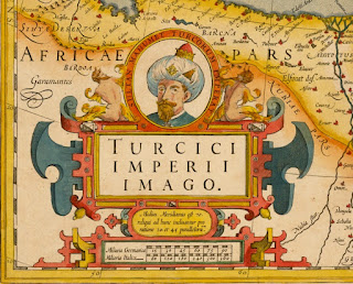
Map of the Turkish Empire, Amsterdam 1606, Jodocus Hondius
Turkish Empire Image
Turcici Imperii Imago, Amsterdam 1606, Jodocus Hondius (1563 – 1612) Map of the Turkish Empire, showing the Turkish territories in the Balkans, Anatolia, Levant, Arabia and North Africa, published by Hondius in "Atlas sive Cosmographicae Meditationes de Fabrica Mundi et Fabricati figura" (Atlas of the world: finely engraved and drawn) in 1606. The map has a decorative cartouche with the portrait of Sultan Mehmet Khan II which refers to him as "Sultan Mahomet Turcorum Imperat 2."
Türk İmparatorluğu Görünümü
Turcici Imperii Imago, Amsterdam 1606, Jodocus Hondius (1563-1612). Balkanlar, Anadolu, Levant, Arabistan ve Kuzey Afrikadaki Türk topraklarını gösteren,Hondius’un “Atlas sive Cosmographicae Meditationes de Fabrica Mundi et Fabricati figura” (Dünyanın atlası: incelikle işlenmiş ve çizilmiş) Dünya Atlasında 1606 yılında yayınlanan, Türk İmparatorluğu haritası. Fatih Sultan Mehmet Han’ nın bir portresi bulunan haritanın dekoratif kitabesinde "Sultan Muhammed Turcarum Imperator 2” ibaresi yer alıyor.


1606 yılına ait Osmanlı Hanedanı yönetimindeki Türk İmparatorluğunu gösteren, Amsterdam' da basılmış, ilgi çekici kitabesi olan bir harita.
ReplyDelete